
Portal:Cities
The Cities Portal

A city is a human settlement of a notable size. The term "city" has different meanings around the world and in some places the settlement can be very small. Even where the term is limited to larger settlements, there is no universally agreed definition of the lower boundary for their size. In a more narrow sense, a city can be defined as a permanent and densely settled place with administratively defined boundaries whose members work primarily on non-agricultural tasks. Cities generally have extensive systems for housing, transportation, sanitation, utilities, land use, production of goods, and communication. Their density facilitates interaction between people, government organizations, and businesses, sometimes benefiting different parties in the process, such as improving the efficiency of goods and service distribution.
Historically, city dwellers have been a small proportion of humanity overall, but following two centuries of unprecedented and rapid urbanization, more than half of the world population now lives in cities, which has had profound consequences for global sustainability. Present-day cities usually form the core of larger metropolitan areas and urban areas—creating numerous commuters traveling toward city centres for employment, entertainment, and education. However, in a world of intensifying globalization, all cities are to varying degrees also connected globally beyond these regions. This increased influence means that cities also have significant influences on global issues, such as sustainable development, climate change, and global health. Because of these major influences on global issues, the international community has prioritized investment in sustainable cities through Sustainable Development Goal 11. Due to the efficiency of transportation and the smaller land consumption, dense cities hold the potential to have a smaller ecological footprint per inhabitant than more sparsely populated areas. Therefore, compact cities are often referred to as a crucial element in fighting climate change. However, this concentration can also have significant negative consequences, such as forming urban heat islands, concentrating pollution, and stressing water supplies and other resources. (Full article...)
Selected city -

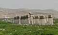
Giza (/ˈɡiːzə/; sometimes spelled Gizah, Gizeh, Geeza, Jiza; Arabic: الجيزة, romanized: al-Jīzah, pronounced [aljiːzah], Egyptian Arabic: الجيزة el-Gīza [elˈgiːzæ]) is the third-largest city in Egypt by area after Cairo and Alexandria; and fourth-largest city in Africa by population after Kinshasa, Lagos, and Cairo. It is the capital of Giza Governorate with a total population of 4,872,448 in the 2017 census. It is located on the west bank of the Nile opposite central Cairo, and is a part of the Greater Cairo metropolis. Giza lies less than 30 km (18.64 mi) north of Memphis (Men-nefer, today the village of Mit Rahina), which was the capital city of the unified Egyptian state during the reign of pharaoh Narmer, roughly 3100 BC.
Giza is most famous as the location of the Giza Plateau, the site of some of the most impressive ancient monuments in the world, including a complex of ancient Egyptian royal mortuary and sacred structures, among which are the Great Sphinx, the Great Pyramid of Giza, and a number of other large pyramids and temples. Giza has always been a focal point in Egypt's history due to its location close to Memphis, the ancient pharaonic capital of the Old Kingdom. (Full article...)Did you know -
- ... that the Housatonic Railroad used to send 100,000 US quarts (95,000 litres) of milk to New York City per day?
- ... that Hurricane Henri, a minimal category 1 hurricane, set a rainfall record in New York City's Central Park?
- ... that developer William Earl Dodge Stokes commissioned a five-story mansion in New York City that he never resided in?
- ... that in 1987, an estimated one-sixth of New York City's homeless children lived at the Martinique Hotel, even though it lacked basic facilities like kitchens?
- ... that the 1937 Fleischer Studios strike in New York City was the first major labor strike in the animation industry?
- ... that the Superior Auditor of the Federation of Mexico observed damage to an overpass between Tezonco and Olivos stations on the Mexico City Metro prior to its collapse in May 2021?
Related portals
Related WikiProjects
 Recognized content -

Canberra (/ˈkænbərə/ ⓘ KAN-bər-ə) is the capital city of Australia. Founded following the federation of the colonies of Australia as the seat of government for the new nation, it is Australia's largest inland city and the eighth-largest Australian city overall. The city is located at the northern end of the Australian Capital Territory at the northern tip of the Australian Alps, the country's highest mountain range. Canberra's estimated population was 466,566.
The area chosen for the capital had been inhabited by Aboriginal Australians for up to 21,000 years, by groups including the Ngunnawal, Ngunawal and Ngambri. European settlement commenced in the first half of the 19th century, as evidenced by surviving landmarks such as St John's Anglican Church and Blundells Cottage. On 1 January 1901, federation of the colonies of Australia was achieved. Following a long dispute over whether Sydney or Melbourne should be the national capital, a compromise was reached: the new capital would be built in New South Wales, so long as it was at least 100 mi (160 km) from Sydney. The capital city was founded and formally named as Canberra in 1913. A plan by the American architects Walter Burley Griffin and Marion Mahony Griffin was selected after an international design contest, and construction commenced in 1913. Unusual among Australian cities, it is an entirely planned city. The Griffins' plan featured geometric motifs and was centred on axes aligned with significant topographical landmarks such as Black Mountain, Mount Ainslie, Capital Hill and City Hill. Canberra's mountainous location makes it the only mainland Australian city where snow-capped mountains can be seen in winter, although snow in the city itself is uncommon. (Full article...)Selected article -

Urban areas usually experience the urban heat island (UHI) effect, that is, they are significantly warmer than surrounding rural areas. The temperature difference is usually larger at night than during the day, and is most apparent when winds are weak, under block conditions, noticeably during the summer and winter. The main cause of the UHI effect is from the modification of land surfaces while waste heat generated by energy usage is a secondary contributor. A study has shown that heat islands can be affected by proximity to different types of land cover, so that proximity to barren land causes urban land to become hotter and proximity to vegetation makes it cooler. As a population center grows, it tends to expand its area and increase its average temperature. The term heat island is also used; the term can be used to refer to any area that is relatively hotter than the surrounding, but generally refers to human-disturbed areas. Urban areas occupy about 0.5% of the Earth's land surface but host more than half of the world's population.
Monthly rainfall is greater downwind of cities, partially due to the UHI. Increases in heat within urban centers increases the length of growing seasons and decreases the occurrence of weak tornadoes. The UHI decreases air quality by increasing the production of pollutants such as ozone, and decreases water quality as warmer waters flow into area streams and put stress on their ecosystems. (Full article...)General images -
-
 View of the Agora of Athens with the temple of Hephaestus to the left and the Stoa of Attalos to the right (from History of cities)
 -
 Daily life of people from the Song period at the capital, Bianjing, today's Kaifeng (from History of cities)
 -
 A map showing the world energy consumption per capita based on 2013 data from the World Bank. (from Urban geography)
 -
 The Round city of Baghdad, the capital of Iraq (from History of cities)
 -
 A poster from the EPA entitled "Soak Up the Rain with Green Infrastructure." The poster depicts various green infrastructure that can be effective in preventing floods. (from Urban geography)
 -
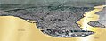
 Extent and major sites of the Indus Valley civilization of ancient India (from History of cities)
 -
-
 This woodcut shows Nuremberg as a prototype of a flourishing and independent city in the 15th century. (from History of cities)
 -
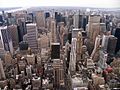 New York City, one of the largest urban areas in the world (from Urban geography)
 -
 Constantinople, the largest and wealthiest city in Europe from the 9th through the 12th century (from History of cities)
 -
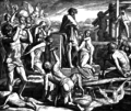 Cain founding the city of Enoch (from History of cities)
 -
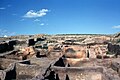 Excavated foundations of Çatalhöyük, Turkey. An Anatolian town dated to 7000 BCE. (from History of cities)
 -
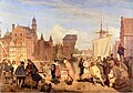 Gdańsk in the 17th century (from History of cities)
 -
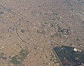
 Aerial photograph shows the remains of the Sumerian city Ur, near Nasiriyah, Iraq. (from History of cities)
 -
 Palmanova, Italy, constructed in 1593 according to the defensive ideal of the star fort, today retains its distinctive geometry. (from History of cities)
 -
-
 The city of Arbil in the Kurdistan Region of Iraq has a radial urban structure centred on an ancient fortress (from Urban structure)
 -
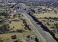 The Avenue of the Dead in Teotihuacan originates with the Pyramid of the Moon, forming the basis of the city grid. (from History of cities)
 -
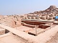 Mohenjo-daro, a World Heritage Site that was part of the Indus Valley civilization (from History of cities)

.jpg)


_LACMA_M.2008.40.98.8.jpg)


Topics
List articles
Subcategories

Associated Wikimedia
The following Wikimedia Foundation sister projects provide more on this subject:
-
 Commons
Free media repository -
 Wikibooks
Free textbooks and manuals -
 Wikidata
Free knowledge base -
 Wikinews
Free-content news -
 Wikiquote
Collection of quotations -
 Wikisource
Free-content library -
 Wikiversity
Free learning tools -
 Wiktionary
Dictionary and thesaurus


